Current project team members: Philip Orton, Mahmoud Ayyad, Marouane Temimi, Jon Miller
The Stevens Flood Advisory System (SFAS) is a unique and widely-used academic coastal total water level forecast system that has provided ensemble forecasts year-round since 2015. SFAS displays both current and forecast water levels at several locations spanning from Cape Hatteras to the Gulf of Maine, with its highest resolution (and primary user base) in the highly populated New York-New Jersey region. SFAS provides time series of central forecast water level and 5th and 95th percentiles to represent uncertainty (Georgas et al. 2016; Jordi et al. 2019). Forecast graphics are posted with data access on the forecast webpage and interested users can sign up to be notified of impending flooding via email warnings. A very wide user base utilizes SFAS, including residents, emergency managers, Hudson River vessel pilots, and the National Weather Service weather forecast offices (NWS WFOs). Over 1300 of these users are signed up to receive flood forecast alerts by email. The NWS WFOs use SFAS numeric forecast data in their Total Water Level forecast system to help inform their forecast guidance. Stevens provides our water level forecast data to WFOs at Upton (NY), Mt. Holly (NJ), Gray (ME) and Norton/Boston (MA).
Project Publications
Ayyad, M., Orton, P.M., El Safty, H., Chen, Z. and Hajj, M.R. (2022). Ensemble forecast for storm tide and resurgence from Tropical Cyclone Isaias. Weather and Climate Extremes, 38, p.100504. open access
Chen et al., Assessment and Improvement of a Mid-latitude Ensemble Coastal Water Level Forecast System, manuscript to be submitted in March 2025.
Georgas, N., et al., (2016). The Stevens Flood Advisory System: Operational H3E flood forecasts for the greater New York/New Jersey Metropolitan Region. Flood Risk Management and Response, 194. open access
Jordi, A., et al., (2019). A next-generation coastal ocean operational system: Probabilistic flood forecasting at street scale. Bulletin of the American Meteorological Society, 100(1), pp.41-54. open access
Orton, P. M., Z. Chen, H. El Safty, M. Ayyad, R. Datla, J. Miller, and M. R. Hajj (2021), Stevens Flood Advisory System 2020 Ensemble Forecast Assessment: NY/NJ Harbor Area, p. 21, Hoboken, New Jersey, USA. open access
Orton, P. M., Z. Chen, H. El Safty, M. Ayyad, R. Datla, J. Miller, and M. R. Hajj (2022), Stevens Flood Advisory System 2021 Ensemble Forecast Assessment: NY/NJ Harbor Area,, p. 23, Hoboken, New Jersey, USA. open access
Funding program: Mid-Atlantic Regional Association of Coastal Ocean Observing Systems (MARACOOS) project “Strengthening Mid-Atlantic Infrastructure, Data Products and Services”
Project Period: February 2023 – January 2028
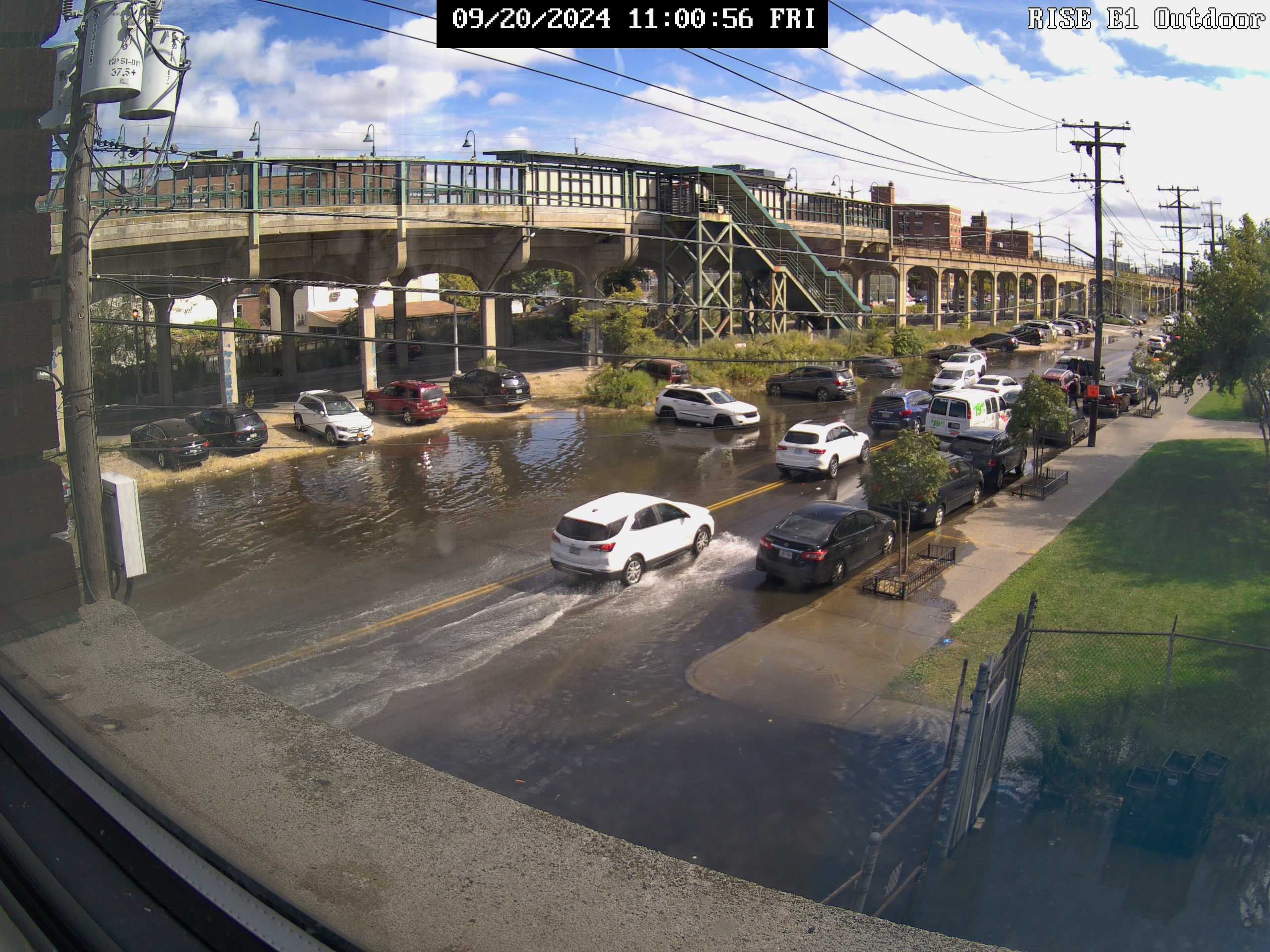
We will create a multi-sensor street coastal flood observation testbed focusing on the most highly populated part of the MARACOOS region, the New York City Metropolitan Area. Overriding long-term objectives are to (1) deploy both cameras on cross-coastal transects in New York and New Jersey, (2) interact with other observation networks (FloodNet, NJFloodNet and WebCOOS) to co-locate cameras with ultrasonic sensors and innovate and test methods for multi-sensor cross-coastal flood observation systems, and (3) develop Machine-Learning (ML) models to enable data-driven prediction of coastal-pluvial flooding to improve public safety. The effort will fill a critical gap in the MARACOOS observing system where rising flood frequencies are impacting some of the region’s most low-lying neighborhoods. High-tide or “nuisance” flooding arises from a combination of rainfall and elevated coastal water levels, yet existing observations at tide gauges cannot capture the water levels where people are impacted. This project will help innovate on-street measurements of flooding and the development of models that can help predict neighborhood flooding along our coasts.
Results
Project-deployed camera observation sites for flooding:
PI Philip Orton, Co-I Kaijian Liu, Stevens Institute of Technology
Co-I Malgosia Madajewicz, Columbia University
Co-I Greg Smithsimon, Brooklyn College
PhD student: Shima Kasaei, Stevens Institute
Project manager/ collaborator: John Warner, US Geological Survey
Funding agency/program: US Geological Survey
Project Period: September 2022 to August 2025
Recent flood disasters arising from coastal storms (e.g., Harvey and Ida) have demonstrated the critical importance of incorporating rainfall into assessments of coastal flood risk. However, studies of present and future coastal flood risk and adaptation nearly always neglect rainfall and thus have biases that may lead to suboptimal government planning decisions. Climate change is leading to both increasing rainfall intensity and rising coastal floods, worsening these biases and the dangers they represent.
Vulnerability to flooding, which includes exposure, defined as living in an area that may flood, susceptibility to suffer damage if flooding occurs, and capacity to recover, differs across communities with different socio-economic characteristics. Prior research characterizes how vulnerability to flooding driven by coastal storms differs in the population in the urban neighborhoods of New York City (NYC). Vulnerability to nuisance, tidal, and pluvial flooding is much less well documented and understood. Impacts of and therefore vulnerability to nuisance and pluvial flooding can differ from coastal storm flooding. For example, anecdotal evidence suggests that the danger posed to residents of basement apartments can be particularly acute in the case of flash flooding driven by extreme rainfall. Residents of basement apartments are often disadvantaged in many ways, being low-income, from minority racial groups, or recent immigrants.
In this study, we will combine novel modeling and assessment of compound coastal-pluvial flood hazard with analyses of flood vulnerability in populations with different characteristics around Jamaica Bay, NYC. Innovative hydrodynamic and machine learning (ML) models will be developed and applied for integrated flood modeling for Jamaica Bay, both validated using existing citizen science observations and ultrasonic sensor measurements of street flooding. We will collect and analyze social data through interviews and household surveys to document impacts of and recovery from flooding in neighborhoods that have recently been impacted by pluvial and high-tide flooding and that represent a broad range of natural and built environmental and socio-economic conditions. We will combine investigation of social vulnerability to pluvial and high-tide flooding with existing understanding of social vulnerability to coastal storm flooding in urban neighborhoods, to assess inequities in the burden of flood risk and inform policies that can advance equitable adaptation to flood risk.
Co-PI Marc Cammarata, Philadelphia Water Department
Additional team members: Julia Rockwell (PWD), Kazi Mita (Stevens), Fatemeh Nasrollahi (Drexel)
Funding agency/program: National Oceanic and Atmospheric Administration, Climate Program Office, Coastal Ocean Climate Applications (COCA)/Sectoral Applications Research Program (SARP)
Project Period: September 2019 to August 2023
Abstract
Compound flooding is the combination of rainfall-induced flooding with storm surge induced flooding, and is currently inadequately considered nationwide in both flood risk assessment and forecasts. It is well-established that coastal floods are becoming more frequent, and the U.S. Northeast has seen a substantial increase in intense rainfall events in recent decades, likely as a result of climate change. In many U.S. cities, coastal and fluvial floods merge in estuaries, causing a compounded problem, and the coincident occurrence of extreme rain and surge is growing at many locations. However, little research has been performed to improve our understanding of compound flooding.
An ideal location to investigate this problem, Eastwick is a low-lying neighborhood in South Philadelphia situated near the Delaware River at the confluence of Darby and Cobb’s Creeks. It is in close proximity to the 1.2 km2 John Heinz National Wildlife Refuge, two federal Superfund sites, a series of oil refineries, and the Philadelphia International Airport, and meets the EPA criteria for an Environmental Justice community, with a majority (76%) of its population being African American, and pockets of low income residents. Triggered by rainfall, coastal surges pushing up the tidal portion of the Delaware River, or some combination of the two, flooding has long been one of the biggest problems facing this community.
The proposed research will inform climate risk management and adaptation decision-making regarding flooding in Eastwick, and will be performed by researchers from two universities and the Philadelphia Water Department (PWD). The project will include four core areas of science, as well as a community engagement process, strong coordination with decision makers and a specific focus on two ongoing city planning initiatives. The core compound flood science research areas include flood modeling, extreme value analysis, climate-impact assessment, and adaptation benefit-cost analysis. The engagement process will consist of two community workshops, including collaborative design of flood adaptation scenarios and a socially-sourced validation of the flood modeling. Coordination with decision makers will occur through an advisory panel, project webinars, and the activities of our team members at the PWD.
The proposed research will strongly further NOAA and COCA/SARP interests relating to climate change. It presents a framework and detailed technical approach for addressing both the communication of risk and the economics of adaptation to compound flooding and climate change. An important additional component of the planned research is to compare our detailed analyses to simplified approaches, to improve the transferability of the work to other communities with similar challenges. The advancement of scientific understanding, prediction and communication of compound flooding will help enable effective decisions, and our development and dissemination of modeling, statistical hazard analysis and benefit-cost analysis tools will have a nationwide impact on resilience.
Publications to date
Mita, K. S., Orton, P., Montalto, F., Saleh, F., & Rockwell, J., 2023. Sea Level Rise-Induced Transition from Rare Fluvial Extremes to Chronic and Compound Floods. Water, 15(14), 2671. DOI: 2073-4441/15/14/2671. open access
Orton, P., Montalto, F. and Cammarata, M., 2024. Public Comment and scientific documentation appendices submitted to the US Army Corps of Engineers in response to its call for public comments for the Draft Integrated Feasibility Report and Environmental Assessment, January 30, 2024, 93 pp. USACE_comments-allsigned
Mita, K. S. (2024). Climate impacts and adaptation assessment for fluvial, coastal and compound flooding. Dissertation for completion of the doctoral degree in the Department of Civil, Environmental and Ocean Engineering, Stevens Institute of Technology, Hoboken, NJ, 160 pp. Kazi Mita_dissertation_final
Introduction
Eastwick is a low-lying community in South Philadelphia that floods frequently yet lacks sufficient information on flood risk or adaptation. It meets the EPA criteria for an Environmental Justice community, with a majority (76%) of its population being African American, and pockets of low income residents. The community is situated near the Delaware River at the confluence of Darby and Cobb’s Creeks, and in close proximity to the 1.2 km2 John Heinz National Wildlife Refuge. Unfortunately, Eastwick also happens to be located next to portions of the Lower Darby Creek Superfund Site, increasing the health risks posed by any flooding that occurs in this area.
Flooding has long been one of the biggest problems facing Eastwick, the lowest-lying community in Philadelphia (University of Pennsylvania, 2017). Eastwick’s floods can be purely due to rainfall, purely due to high coastal sea levels pushing up the tidal Delaware River, or they can be compound flooding (Moftakhari et al., 2017; Wahl et al., 2015), the merger of the two (U.S. Army Corps of Engineers, 2014). As such, the community exemplifies a common problem faced by low-lying coastal neighborhoods located at the downstream end of coastal urbanized watersheds found across the nation. Eastwick has been designated by FEMA as a Special Flood Hazard Area. In 1999, for example, Hurricane Floyd deposited 25 cm of rain in the Darby Creek watershed and pushed a 0.85 m surge up the Delaware River, creating such severe flooding that residents had to be rescued by rowboat. After Hurricane Irene’s (runoff-induced) flood and just before Hurricane Sandy’s (surge-induced) flood, the Mayor called for a comprehensive solution to Eastwick’s flooding problems, yet to date no comprehensive mitigation plan for the neighborhood has been developed.
Compound flooding is currently inadequately considered nationwide in both flood risk assessment and modeling activities. Neither FEMA’s maps, nor NOAA’s forecasts address compound flooding because they address runoff-induced or surge-derived flooding separately (e.g., Corelogic, 2017a; Moftakhari et al., 2017; Orton et al., 2012). For example, Philadelphia is ranked as being the metro area with the 11th-highest hurricane storm surge risk in the US (Corelogic, 2017b), but that study did not account for rainfall. Flood modelers often either assume constant stream flow, if they are simulating surge-derived floods, or a static coastal water level if they are simulating runoff-induced riverine floods (e.g., U.S. Army Corps of Engineers, 2014). Holistic simulation and probabilistic assessment of compound flooding is thus essential to “risk characterization” and to “the development of innovative, applicable, and transferable approaches for decision making” in urban coastal communities across the nation (two key goals of the CSI program).
Proposed study and objectives
The overriding objective of the proposed research is to inform climate risk management and decision-making regarding flooding in Eastwick. The proposed research activities will be integrated into two ongoing community planning initiatives: (1) the City-wide Flood Risk Management Task Force which was first convened in 2015 “to address the circumstances of flooding as it impacts various Philadelphia neighborhoods” including Eastwick (PWD, 2017a) and (2) the Lower Eastwick Public Land Strategy (LEPLS), a planning effort that has developed and will now begin to implement a vision for Eastwick’s vacant and publicly-owned land (RDA, 2017). Our interactions with the Task Force will be facilitated principally by project partner Philadelphia Water Department (PWD) with Co-PI Joanne Dahme and PWD project manager Julia Rockwell, while our interaction with the LEPLS (Figure 1) will be through our partners at Keystone Conservation Trust and the Eastwick Friends and Neighbors Coalition.
Figure 1: Diagram of the proposed COCA/SARP project (top) as well as the timeline of projects with which the study would connect or leverage (bottom).
The research team will improve an existing dynamic model of compound flooding in Eastwick developed by the project team and use it in conjunction with ongoing and proposed new stakeholder activities in several inter-related ways. The land use strategies developed by the LEPLS team will be incorporated into the model domain, ensuring that future climate impacts and adaptation scenarios respond to the community’s expressed aspirations and goals regarding local land cover and land use. New workshops planned by the project team will be used to validate retrospective model simulations with local knowledge regarding the location, timing and severity of historical flooding in the community (a “social validation”). These workshops will also source community-guided green and grey flood adaptation measures across the watersheds and waterfronts (e.g. Figure 2). The efficacy of these measures for mitigating flooding will be quantified with dynamic flood modeling of historical and synthetic flood events across a wide range of return periods (e.g. Figure 3). Damage computations for flooding and benefit-cost ratios will be computed using improved city data within FEMA’s HAZUS software.
Figure 2: Co-PI Montalto and his students listening to community leaders with Eastwick Friends and Neighbors Coalition (EFNC) at last year’s flooding workshop.
These activities will be coordinated through and at times conducted during regularly scheduled meetings of the City-wide Task Force, minimizing the time commitment that our engagement activities will have on local stakeholders, while also ensuring participation of a diverse and representative group of intended beneficiaries in the research. This synchronization will ensure that the research outputs are both timely and germane, given other planned activities in this dynamic community.
In this way, we will test innovative, broadly applicable approaches for flood modeling, flood risk assessment, benefit-cost analysis of compound flood risk reduction scenarios. Key contributions of the research to the science of climate adaptation and engagement will be: a) an evaluation of the proposed stakeholder-engaged modeling approach as a means of communicating complex probabilistic, multi-source flood risks to a vulnerable community, b) development of a workshop framework that can be used to explore the advantages and disadvantages of alternative adaptation strategies under a wide range of compound flood risk scenarios.
Figure 3: Example of modeled flooding (shaded water depth in feet) for a synthetic storm event with Hurricane Sandy’s Delaware River water levels combined with Hurricane Irene’s Cobbs-Darby streamflows. Eastwick spans the top-right to the center-right.
Moftakhari, H. R., Salvadori, G., AghaKouchak, A., Sanders, B. F., & Matthew, R. A. (2017). Compounding effects of sea level rise and fluvial flooding. Proceedings of the National Academy of Sciences, 114(37), 9785-9790.
Orton, P., Georgas, N., Blumberg, A., & Pullen, J. (2012). Detailed modeling of recent severe storm tides in estuaries of the New York City region. Journal of Geophysical Research, 117, C09030. doi: 10.1029/2012JC008220
U.S. Army Corps of Engineers. (2014). Eastwick Stream Modeling and Technical Evaluation Philadelphia, Pennsylvania, Philadelphia District, North Atlantic Division.
Wahl, T., Jain, S., Bender, J., Meyers, S. D., & Luther, M. E. (2015). Increasing risk of compound flooding from storm surge and rainfall for major US cities. Nature Climate Change, 5(12), 1093-1097.
PI Stefan Talke, Portland State University / California Polytechnic State University
Funding agency/program: National Science Foundation, Prediction of and Resilience to Extreme Events (PREEVENTS)
Project Period: June 2019 to May 2024 (completed)
Below are (a) a summary, (b) list of peer-reviewed publications and (c) datasets, codes and tools.
SUMMARY
In this collaborative research between four universities we investigated how and why changing flood risk in estuaries is influenced by direct, human activities but also natural variability and climate trends. The increased flood hazard caused by sea level rise and U.S. coastal population growth are well known. Less studied, however, is how flooding in estuaries is changing due to geomorphic changes such as dredging and both natural and climatic variability. The characteristics of storm surge and coastal flooding depend on both far-field forcing (meteorological, oceanographic) and on local characteristics (estuary bathymetry, floodplain land cover). As a result, changes to any of these factors may greatly influence flood hazard. In many locations, the local changes are huge: since the 19th century, estuary channels have typically been deepened and widened by a factor of two or three, harbor entrances have been deepened and streamlined, and a large proportion of wetlands have been lost to landfill development. Our research shows that such geomorphic changes, which can be referred to as estuary urbanization, increase flood risk by reducing natural resistance to storm surge and tides. Similarly, sea level rise, natural (astronomically-forced) variations in tides, and variable storm characteristics such as storm track, speed, or size also alter flood risk.
Our results are helping to show that estuary urbanization can have a major impact on flood hazards, worsening both storm surge and high-tide flooding. Increases in tidal amplitudes are exacerbating nuisance (“high tide”) flooding at nearly half of the long-term measurement sites evaluated (18 of 40 NOAA gauges). The number of nuisance floods was 27% higher in 2019 at those 18 locations than it would have been without tidal amplitude increases. Our evidence and computer modeling show that any hurricane storm surge affecting parts of New York City, Jacksonville, Wilmington, Philadelphia and South Florida, among other locations, will likely produce higher water levels due to estuary urbanization, potentially causing more damage in unprotected regions.
Figure caption: Processes affecting coastal flooding in modern versus historical estuaries.Storm surge is formed mainly by wind over water, and acts together with tidal forcing to produce a storm tide. This external wave is modified by local bathymetry and wind: Converging width (as shown) amplifies heights, frictional effects damp (reduce) the wave, and tide/surge waves interact nonlinearly. Historical estuary bathymetry was shallower, more rough, and included more wetlands and intertidal areas. Geomorphic change affects local wind setup (by changing estuary surface area and the ratio of surface stress τ to depth H). Moreover, estuarine alterations also reduced frictional effects on wave amplitude η, both thru decreased drag coefficient Cd and increased depth H. Change in timescale T –set by the speed, size, and path of a cyclone, for a surge—also impact magnitudes.
Our research is also helping to reveal and contrast the mechanisms by which climate and weather variability and geomorphic changes alter flood risk. Increases in storm surge (for the same meteorological forcing) are often strongest in urbanized estuaries that previously had natural features that reduced surges (e.g., the Saint Johns Estuary). Idealized modeling of storm surge shows that the amount of change due to channel deepening also depends on tide-surge non-linear frictional effects, the time scale of the surge (fast or slow), the frequency of the major tide forcing, and the magnitude or river flow. Large increases in tides and storm surge water levels are also often observed at estuary boundaries, both due to long-wave reflection effects but also sometimes resonance. Finally, our research shows that natural variations in tides, for example over the 18.6 year nodal cycle and the 8.85 year cycle of lunar perigee, influence the risk of major floods in about 70% of the 551 gauges evaluated. In Boston, the area of the 100 year floodplain varies by about 45% over a 18.6 year cycle (under current sea-level conditions).
We also developed methods for attribution of flooding to climate change and geomorphic change. The roles of geomorphic change and climate change on flooding were contrasted for New York City’s heavily urbanized Jamaica Bay, revealing that geomorphic change has had a similar influence as climate change driven sea level rise. For most coastal sites, however, sea level rise has a larger impact than geomorphic change.
This project also provides a new understanding of how weather variability can determine flood characteristics. For example, research showed that the interaction of storms and blocking anticyclones can lead to persistent storm surge events for the Northeastern US. For tropical cyclone events along the East Coast occurring over the last half century, the project provided a sensitivity analysis relating storm surge events to storm characteristics such as storm strength, forward speed and approach angle. It also provided benchmarks on storm surge probabilities. Work examining the spatial footprints of storms showed regions in which flood risk is coherent. In the future, all these efforts can help improve models, and provide avenues for using less spatially and temporally complete historical data to improve understanding of past climate change.
The project leveraged interactions with several governmental entities to broaden the reach of our findings – The New York City Office of Restoration and Resilience (via the NYC Panel on Climate Change), the US Geological Survey and the US Army Corps of Engineers. It also provided significant support for three early career principal investigators, 5 postdoctoral research associates, 5 PhD students, 6 MS students, and 3 undergraduates and 2 high school students, with several of these coming from groups that are underrepresented in academic science.
PROJECT PUBLICATIONS
Baranes, H. E. and Woodruff, J. D. and Talke, S. A. and Kopp, R. E. and Ray, R. D. and DeConto, R. M. “Tidally Driven Interannual Variation in Extreme Sea Level Frequencies in the Gulf of Maine” Journal of Geophysical Research: Oceans , v.125 , 2020 https://doi.org/10.1029/2020JC016291
Booth, James F. and Narinesingh, Veeshan and Towey, Katherine L. and Jeyaratnam, Jeyavinoth “Storm Surge, Blocking, and Cyclones: A Compound Hazards Analysis for the Northeast United States” Journal of Applied Meteorology and Climatology , 2021 https://doi.org/10.1175/JAMC-D-21-0062.1
Chen, Ziyu and Orton, Philip and Wahl, Thomas “Storm Surge Barrier Protection in an Era of Accelerating Sea-Level Rise: Quantifying Closure Frequency, Duration and Trapped River Flooding” Journal of Marine Science and Engineering , v.8 , 2020 https://doi.org/10.3390/jmse8090725
Calafat, Francisco M. and Wahl, Thomas and Tadesse, Michael Getachew and Sparrow, Sarah N. “Trends in Europe storm surge extremes match the rate of sea-level rise” Nature , v.603 , 2022 https://doi.org/10.1038/s41586-022-04426-5
De Leo, F. and Talke, S. A. and Orton, P. M. and Wahl, T. “The Effect of Harbor Developments on Future High-Tide Flooding in Miami, Florida” Journal of Geophysical Research: Oceans , v.127 , 2022 https://doi.org/10.1029/2022JC018496
Devlin, Adam T. and Jay, David A. and Talke, Stefan A. and Pan, Jiayi “Global water level variability observed after the Hunga Tonga-Hunga Ha’apai volcanic tsunami of 2022” Ocean Science , v.19 , 2023 https://doi.org/10.5194/os-19-517-2023
Enriquez, Alejandra R and Wahl, Thomas and Talke, Stefan A and Orton, Philip M and Booth, James F and Agulles, Miguel and Santamaria-Aguilar, Sara “MatFlood: An efficient algorithm for mapping flood extent and depth” Environmental Modelling & Software , v.169, 2023 https://doi.org/10.1016/j.envsoft.2023.105829
Enríquez, Alejandra R. and Wahl, Thomas and Baranes, Hannah E. and Talke, Stefan A. and Orton, Philip M. and Booth, James F. and Haigh, Ivan D. “Predictable Changes in Extreme Sea Levels and Coastal Flood Risk Due To Long?Term Tidal Cycles” Journal of Geophysical Research: Oceans , v.127 , 2022 https://doi.org/10.1029/2021JC018157
Enríquez, Alejandra R. and Wahl, Thomas and Marcos, Marta and Haigh, Ivan D. “Spatial Footprints of Storm Surges Along the Global Coastlines” Journal of Geophysical Research: Oceans , v.125 , 2020 https://doi.org/10.1029/2020JC016367
Fang, Jiayi and Wahl, Thomas and Zhang, Qiang and Muis, Sanne and Hu, Pan and Fang, Jian and Du, Shiqiang and Dou, Tingfeng and Shi, Peijun “Extreme sea levels along coastal China: uncertainties and implications” Stochastic Environmental Research and Risk Assessment , v.35 , 2021 https://doi.org/10.1007/s00477-020-01964-0
Familkhalili, Ramin and Talke, Stefan A. and Jay, David A. “Compound flooding in convergent estuaries: insights from an analytical model” Ocean Science , v.18 , 2022 https://doi.org/10.5194/os-18-1203-2022
Familkhalili, R. and Talke, S. A. and Jay, D. A. “Tide-Storm Surge Interactions in Highly Altered Estuaries: How Channel Deepening Increases Surge Vulnerability” Journal of Geophysical Research: Oceans , v.125 , 2020 https://doi.org/10.1029/2019JC015286
Hague, Ben S. and Grayson, Rodger B. and Talke, Stefan A. and Black, Mitchell T. and Jakob, Dörte “The effect of tidal range and mean sea-level changes on coastal flood hazards at Lakes Entrance, south-east Australia” Journal of Southern Hemisphere Earth Systems Science , 2023 https://doi.org/10.1071/ES22036
Haigh, Ivan D. and Marcos, Marta and Talke, Stefan A. and Woodworth, Philip L. and Hunter, John R. and Hague, Ben S. and Arns, Arne and Bradshaw, Elizabeth and Thompson, Philip “GESLA Version 3: A major update to the global higher?frequency sea?level dataset” Geoscience Data Journal , 2022 https://doi.org/10.1002/gdj3.174
Latapy, Alexa and Ferret, Yann and Testut, Laurent and Talke, Stefan and Aarup, Thorkild and Pons, Frederic and Jan, Gwenaele and Bradshaw, Elizabeth and Pouvreau, Nicolas “Data rescue process in the context of sea level reconstructions: An overview of the methodology, lessons learned, up?to?date best practices and recommendations” Geoscience Data Journal , 2022 https://doi.org/10.1002/gdj3.179
Li, Linjiang and Zhu, Jianrong and Pareja-Roman, L. Fernando “Calculating salinity variance fluxes using isohaline coordinates” Estuarine, Coastal and Shelf Science , v.254 , 2021 https://doi.org/10.1016/j.ecss.2021.107311
Li, Sida and Wahl, Thomas and Talke, Stefan A. and Jay, David A. and Orton, Philip M. and Liang, Xinghui and Wang, Guocheng and Liu, Lintao “Evolving tides aggravate nuisance flooding along the U.S. coastline” Science Advances , v.7 , 2021 https://doi.org/10.1126/sciadv.abe2412
Li, S. and Wahl, T. and Fang, J. and Liu, L. and Jiang, T. “High-Tide Flooding Along the China Coastline: Past and Future” Earth’s Future , v.11 , 2023 https://doi.org/10.1029/2022EF003225
Li, Linjiang and Zhu, Jianrong and Chant, Robert J. and Wang, Chuning and Pareja?Roman, L. Fernando “Effect of Dikes on Saltwater Intrusion Under Various Wind Conditions in the Changjiang Estuary” Journal of Geophysical Research: Oceans , v.125 , 2020 10.1029/2019JC015685
Nicholls, Robert J. and Beaven, Richard P. and Stringfellow, Anne and Monfort, Daniel and Le Cozannet, Gonéri and Wahl, Thomas and Gebert, Julia and Wadey, Matthew and Arns, Arne and Spencer, Kate L. and Reinhart, Debra and Heimovaara, Timo and Santos, Ví “Coastal Landfills and Rising Sea Levels: A Challenge for the 21st Century” Frontiers in Marine Science , v.8 , 2021 https://doi.org/10.3389/fmars.2021.710342
Nicholls, Robert J. and Hanson, Susan E. and Lowe, Jason A. and Slangen, Aimée B. A. and Wahl, Thomas and Hinkel, Jochen and Long, Antony J. “Integrating new sea?level scenarios into coastal risk and adaptation assessments: An ongoing process” WIREs Climate Change , v.12 , 2021 https://doi.org/10.1002/wcc.706
Orton, Philip M. and Sanderson, Eric W. and Talke, Stefan A. and Giampieri, Mario and MacManus, Kytt “Storm tide amplification and habitat changes due to urbanization of a lagoonal estuary” Natural Hazards and Earth System Sciences , v.20 , 2020 https://doi.org/10.1029/2022JC018777
Pareja-Roman, L. Fernando and Orton, P. M. and Talke, S. A. “Effect of Estuary Urbanization on Tidal Dynamics and High Tide Flooding in a Coastal Lagoon” Journal of Geophysical Research: Oceans , v.128 , 2023 https://doi.org/10.1029/2022JC018777
Strauss, Benjamin H. and Orton, Philip M. and Bittermann, Klaus and Buchanan, Maya K. and Gilford, Daniel M. and Kopp, Robert E. and Kulp, Scott and Massey, Chris and Moel, Hans de and Vinogradov, Sergey “Economic damages from Hurricane Sandy attributable to sea level rise caused by anthropogenic climate change” Nature Communications , v.12 , 2021 https://doi.org/10.1038/s41467-021-22838-1
Tadesse, Michael Getachew and Wahl, Thomas and Rashid, Md Mamunur and Dangendorf, Sönke and Rodríguez-Enríquez, Alejandra and Talke, Stefan Andreas “Long-term trends in storm surge climate derived from an ensemble of global surge reconstructions” Scientific Reports , v.12 , 2022 https://doi.org/10.1038/s41598-022-17099-x
Talke, S. A. and Familkhalili, R. and Jay, D. A. “The Influence of Channel Deepening on Tides, River Discharge Effects, and Storm Surge” Journal of Geophysical Research: Oceans , v.126 , 2021 https://doi.org/10.1029/2020JC016328
Towey, Katherine L. and Booth, James F. and Rodriguez Enriquez, Alejandra and Wahl, Thomas “Tropical cyclone storm surge probabilities for the east coast of the United States: a cyclone-based perspective” Natural Hazards and Earth System Sciences , v.22 , 2022 https://doi.org/10.5194/nhess-22-1287-2022
Treu, Simon and Muis, Sanne and Dangendorf, Sönke and Wahl, Thomas and Oelsmann, Julius and Heinicke, Stefanie and Frieler, Katja and Mengel, Matthias “Reconstruction of hourly coastal water levels and counterfactuals without sea level rise for impact attribution” Earth System Science Data , v.16 , 2024 https://doi.org/10.5194/essd-16-1121-2024
Zhang, Fanglin and Orton, Philip M. “Importance of Neighborhood Aspect Ratio and Storm Climate to Adaptation Efforts to Reduce Coastal Flood Mortality” Frontiers in Built Environment , v.7 , 2022 https://doi.org/10.3389/fbuil.2021.769161
Archival hourly water level data developed for and used in Talke et al. (2020), Talke et al. (2021) and de Leo et al. (2022) is available in the GESLA-3 data set described in Haigh et al., (2023) and available here: https://gesla787883612.wordpress.com/
Future projections of flooding and historical Biscayne Bay bathymetry from De Leo et al. (2022) are available at https://doi.org/10.5281/zenodo.6551549.
Archival water level data from the 1980s-2007 were acquired as part of the PREEVENTS project from the US Geological Survey for Dykstra et al. (2024). These data have now been made available at https://waterdata.usgs.gov/
Data on Jamaica Bay’s historical landscape change (1870s versus present-day), tides and high-tide flooding are published and available at https://doi.org/10.5281/zenodo.4776403.
The detrended storm surge data used in Booth et al. (2021) Towey et al. (2022) are available on the Harvard Dataverse: https://doi.org/10.7910/DVN/NGTGXY
The extratropical cyclone tracks detected and used in Booth et al. (2021) are available on the Harvard Dataverse: https://doi.org/10.7910/DVN/YC3STT
References and links to open-source and other data sets used in the project can be found in data availability statements in the linked publications, and in manuscript supplements.
Team member / Collaborative Lead: Bennett Brooks, Consensus Building Institute
Team member / End-User: Kristin Marcell, New York State DEC, Hudson River Estuary Program, and Cornell University Water Resources Institute
Team member / End-User: Sarah Fernald, New York State DEC, NOAA Hudson River National Estuarine Research Reserve
Funding: NOAA National Estuarine Research Reserve Science Collaborative, with supplementary funds from the New York State Energy Research and Development Authority (NYSERDA)
Project periods – October 2018 through February 2020 (NOAA) and October 2019 through August 2020 (NYSERDA)
Note: This project has ended, and final outputs and reports are listed at the bottom of this page.
Project Summary
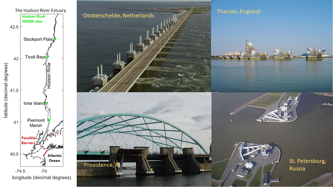
Coastal cities around the country are exploring structural engineering options for defending against extreme storms and the resulting surges of ocean water that cause massive flooding. Storm surge barriers or tide gates can effectively protect harbors and minimize flooding, property damage, and loss of life during large storms. These barriers typically span the opening to a harbor or river mouth and include gates that are only closed when storm surges are expected. However, even when gates are open, the barriers may reduce water flow and tidal exchange, which in turn could affect water quality and ecological processes. A study of this topic is currently underway in the New York metropolitan area, an area with highly valuable and vulnerable coastal infrastructure. The U.S. Army Corps of Engineers, states of New York and New Jersey, and New York City are partnering under the Harbor and Tributaries Focus Area Feasibility Study (HATS) to evaluate surge barriers and other options to manage coastal storm risks.
Scientists and engineers are increasingly recognizing the need for collaboration on research that more fully explores the advantages and disadvantages of large surge barriers. The National Estuarine Research Reserve Science Collaborative funded a “Catalyst” project for one year with the following goals: (1) to facilitate development of a collaborative research agenda that can help interested parties better understand potential barrier effects on nearby estuaries, and (2) to undertake targeted research in close collaboration and with information-sharing among scientists and key end-users such as the U.S. Army Corps of Engineers and its partners. The project team will conduct modeling and analyses of the physical influences of surge barriers and host a series of workshops to synthesize and share information.
Anticipated Benefits
Improved understanding of the benefits and impacts of storm surge barriers on the Hudson River and the surrounding estuarine system.
Enhanced engagement and collaboration among the research community to expand studies of storm surge barriers.
More scientific input to the Harbor and Tributaries Focus Area Feasibility Study, allowing the Army Corps and its partners to consider a range of costs and benefits of surge barriers.
Increased coordination and understanding between the scientific community and key end users in the New York metropolitan area, providing a foundation for future collaborative efforts.
Project Approach
The project approach is designed to foster close collaboration and information-sharing among scientists and key end users. An advisory committee is providing input to the project team to ensure that data analyses and workshop plans are responsive to the needs of end users, such as the Army Corps of Engineers and relevant city and state agency offices. The project team is organizing a series of three to four workshops that will focus on framing the group’s collective understanding of the benefits and impacts of barriers, highlighting areas for future research or discussion, and catalyzing new collaborative research efforts. In addition to key end users and project advisors, the team is inviting additional experts on estuaries and surge barriers to some of the workshops to help address the specific topics and areas of uncertainty identified in prior meetings. The project team is summarizing workshop presentations and discussions into targeted reports and creating a future scope of work that will outline key research needs and lessons learned from the project.
Concurrently, the team is conducting hydrodynamic modeling and scenario data analyses to better understand the physical and ecological effects of a surge barrier on the Hudson River estuary and provide the Army Corps with information to inform their study. The team has models of tides, wind waves, storm surge, and three-dimensional estuarine circulation, as well as a large database of historical simulations and hypothetical storm simulations and probabilities from a prior risk assessment study, which includes both coastal flooding and inland rain flooding along the Hudson. These modeling tools will be used to address specific questions of interest to end users, such as how different barriers would affect tidal range, salinity, stratification, wave impacts, or rain-driven flooding behind a closed barrier.
Targeted End Users
The project advisory committee and workshops are engaging a range of organizations that could use the results in different ways. Targeted end users include non-profit organizations and research institutes invested in this topic, as well as the federal, state, and city offices in New Jersey and New York that have authority to manage coastal storm risks.
Project Outputs
Peer-Reviewed Publications
Paper #1 – Chen, Z., P. M. Orton, and T. Wahl (2020), Storm Surge Barrier Protection in an Era of Accelerating Sea Level Rise: Quantifying Closure Frequency, Duration and Trapped River Flooding, Journal of Marine Science and Engineering, 8(9), 725, doi:10.3390/jmse8090725. open access
Paper #2 – Chen, Z., & Orton, P. M. (2023). Effects of Storm Surge Barrier Closures on Estuary Saltwater Intrusion and Stratification. Water Resources Research, e2022WR032317, doi: 10.1029/2022WR032317. web | temporary free access
Paper #3 – Orton, P. M., Ralston, D., van Prooijen, B., Secor, D., Ganju, N. K., Chen, Z., et al. (2023). Increased utilization of storm surge barriers: A research agenda on estuary effects. Earth’s Future. doi.10.1029/2022EF002991. open access
A presentation was given by Philip Orton, with Co-author Ziyu Chen, titled “Assessing the Physical Effects of Storm Surge Barriers on the Harbor and Hudson River Estuary”. This research continues as Ziyu’s PhD dissertation, so feel free to check in with him on progress.
Data and codes for Paper #1 – Python codes and datasets for barrier closure frequency-duration analysis, trapped river water levels, and trapped water extreme value analysis.
Data and codes for Paper #2 – (1) NYHOPS/sECOM landscape elevation data (DEM) for (a) control model (CSV) (b) Alt3A barriers model. (2) Other data useful for reproducing model simulations (e.g. river, tide boundary conditions).
The diverse populations of the northeastern United States face unique and growing vulnerabilities to extreme weather events. Decision makers and communities, often with support from the Consortium for Climate Risk in the Urban Northeast (CCRUN), have pioneered innovative resilience/adaptation experiments in response. The goal of CCRUN Phase III is to accelerate transformational resilience by addressing five adaptation challenges. Specifically, the need for more: 1) nuanced and actionable climate risk information; 2) robust evaluation of adaptation; 3) consideration of equity and justice; 4) coordination across spatial scales; and 5) integration of mitigation and adaptation.
To address these challenges, Phase III has an interdisciplinary team of natural, applied, and social scientists, with deep stakeholder relationships and core competencies in the Topic Areas of climate science, coasts and floods, public health, engineering and urban design, equity, and social, behavioral, and economic science. CCRUN proposes to conduct collaborative research in these Topic Areas to provide the consistency and continuity of information that underlay the region’s adaptation advances in CCRUN Phases I and II. Additionally, we now propose Integrated Projects focused on 1) Compound extreme events; 2) Coastal and inland flooding; 3) Urban-rural linkages; and 4) Alignment of sustainability, adaptation, and emissions reductions goals in resilience planning. While each project employs context-specific methodologies, several overarching approaches will guide CCRUN’s engagement with decision-makers: knowledge exchange, needs assessment, community-scale capacity building, and web-based tools. In Phase III we seek to connect our place-based research to the broader RISA network, as our Topic Areas and Integrated Projects are linked to regional and national climate impacts and adaptation needs.
Coasts and Floods Sector: Phase I and II accomplishments
CCRUN’s “Coastal Sector” (henceforth its “Coasts and Floods” Group) has produced innovative research on storm surge, climate change impacts, compound riverine-coastal flooding, flood hazard and risk assessment, and adaptation assessment, often under advisement or in co-production processes with stakeholders. In Phase I, research focused on coastal climate risk information; in Phase II it broadened to include flood forecasting and adaptation analysis.
Our innovations in climate risk information have advanced based on stakeholder interests from mapping sea level rise effects on extreme flooding (Horton et al., 2015; Orton et al., 2015) to mapping its effects on recurrent tidal flooding (Supplemental Figure A; Orton et al., 2019; Patrick et al., 2019). Our research quantifying the importance of compound flooding in flood hazard assessment (Orton et al., 2012; Orton et al., 2018) has been influential toward NOAA’s evolving goal of integrated water modeling and forecasting. These innovations are captured in online flood hazard mappers (all linked from the Climate Resilience Toolkit) for NYC, NYS, Jamaica Bay (NYC), and Boston. This research has used hydrodynamic modeling to quantify the efficacy of nature-based adaptations that reduce flood risk (e.g., Marsooli et al., 2017) or conversely, the rise in risk that can occur from estuary urbanization (Orton et al. 2020; Li et al. in press). Educating the next generation of coastal climate service scientists has also been a focus. In two PhD dissertation projects, we evaluated metrics of gray infrastructure and climate change, including how gated storm surge barriers would perform under accelerating sea level rise (Z. Chen et al., 2020) and how grey structural flood protection affects human mortality risk (F. Zhang et al., 2020).
We have heard growing concerns from local governments and communities in NYC, Camden, Philadelphia and Boston about rainfall, river, sewer and compound flooding. For Phase III the “Coastal” sector will expand to become the Coasts and Floods Group by increasing our inland flooding capabilities. We have added hydrologist Marouane Temimi, who works closely with NOAA National Water Center on the enhancement of the National Water Model in the Northeast.
Research capabilities include flood and wave modeling (Marsooli et al., 2017; P. M. Orton et al., 2020), hydrologic modeling (Gonzalez et al., 2015), coupling of atmospheric and hydrological processes (Wehbe et al., 2019), remote sensing of hydrological processes (e.g., Temimi et al., 2011), in situ observation of soil hydraulic parameters (Al Jassar et al., 2019; Temimi et al., 2014), compound rainfall-river-coastal flood modeling (Orton et al., 2012; Orton et al., 2018), remote sensing of coastal processes (Chaouch et al., 2012), estuary circulation and water quality modeling hazard assessment (P.M Orton et al., 2015, 2016; P. M. Orton et al., 2018), damage and mortality modeling (P. Orton et al., 2016; F. Zhang et al., 2020), adaptation assessment (P. M. Orton et al., 2015), as well as operational coastal-hydrologic ensemble flood forecasting (Jordi et al., 2019).
Coasts and Floods Sector: Phase III plans
In Phase III, the Coasts and Floods Group will take on the following set of task areas, in addition to participation in Integrated Projects:
Provide on-demand climate risk information and research: This will build upon existing efforts for Philadelphia and NYC, but also including scheduled briefings with Jersey City, Camden and Boston to deepen these connections and address identified needs.
Study climate and urbanization impacts on inland, coastal and compound flooding, building upon our collaborative COCA/SARP-funded research (Orton and Montalto) and Orton’s NSF-funded research on separating climatic and estuary urbanization effects on flooding.
Quantify climate attribution for coastal flooding: In collaboration with the climate group above, we will operationalize estimation of effects of climate change within our real-time flood forecast system’s website, working with stakeholders to evaluate the impact.
Expand forecasting to include flood forecast mapping and improved communication. A deficiency in coastal flood observation systems is the lack of street-level observations, and we have begun deployments and research on webcam and ultrasonic sensor flood observations. These helps improve our models and enable flood forecast mapping.
Project publications
Mita, K. S., Orton, P., Montalto, F., Saleh, F., & Rockwell, J., 2023. Sea Level Rise-Induced Transition from Rare Fluvial Extremes to Chronic and Compound Floods. Water, 15(14), 2671. DOI: 2073-4441/15/14/2671. open access
Orton, P. M., Ralston, D., van Prooijen, B., Secor, D., Ganju, N. K., Chen, Z., Fernald, S., Brooks, B. and Marcell, K., 2023. Increased utilization of storm surge barriers: A research agenda on estuary effects. Earth’s Future. doi.10.1029/2022EF002991. open access
Chen, Z., & Orton, P. M., 2023. Effects of Storm Surge Barrier Closures on Estuary Saltwater Intrusion and Stratification. Water Resources Research, e2022WR032317, doi: 10.1029/2022WR032317. web | temporary free access
Pareja-Roman, L. F., Orton, P. M., & Talke, S. A., 2023. Effect of estuary urbanization on tidal dynamics and high tide flooding in a coastal lagoon. Journal of Geophysical Research: Oceans, 128, e2022JC018777, doi:10.1029/2022JC018777. open access
Ayyad, M., P. M. Orton, H. E. Safty, Z. Chen, and M. R. Hajj, 2022. Ensemble Forecast for Storm Tide and Resurgence from Tropical Cyclone Isaias, Weather and Climate Extremes, doi:10.1016/j.wace.2022.100504. web
Zhang, F., P. M. Orton, M. Madajewicz, S. C. K. Jagupilla, and R. Bakhtyar (2020), Mortality during Hurricane Sandy: The effects of waterfront flood protection on Staten Island, New York, Natural Hazards, doi:10.1007/s11069-020-03959-0. open access.
Orton, P., N. Lin, V. Gornitz, B. Colle, J. Booth, K. Feng, M. Buchanan, and M. Oppenheimer (2019), New York City Panel on Climate Change 2019 Report Chapter 4: Coastal Flooding, Ann. N. Y. Acad. Sci., 1439, 95-114, doi:10.1111/nyas.14011. open access
Patrick, L., W. Solecki, V. Gornitz, P. Orton, and A. Blumberg (2019), New York City Panel on Climate Change 2019 Report Chapter 5: Mapping Climate Risk, Ann. N. Y. Acad. Sci., 1439, 115-125, doi:10.1111/nyas.14015. open access
Gornitz, V., M. Oppenheimer, R. Kopp, P. Orton, M. Buchanan, N. Lin, R. Horton, and D. Bader (2019), New York City Panel on Climate Change Chapter 3: Sea Level Rise, Ann. N. Y. Acad. Sci., 1439, 71-94, doi:10.1111/nyas.14006. open access
Orton, P. M., F. R. Conticello, F. Cioffi, T. M. Hall, N. Georgas, U. Lall, A. F. Blumberg, and K. MacManus (2018). Flood hazard assessment from storm tides, rain and sea level rise for a tidal river estuary, Natural Hazards, 1-29, doi:10.1007/s11069-018-3251-x. web | PDF.
Kemp, A. C., T. D. Hill, C. H. Vane, N. Cahill, P. M. Orton, S. A. Talke, A. C. Parnell, K. Sanborn, and E. K. Hartig (2017). Relative sea-level trends in New York City during the past 1500 years, The Holocene, 0959683616683263. PDF | web
Orton, P. M., Hall, T. M., Talke, S., Blumberg, A. F., Georgas, N., & Vinogradov, S. (2016). A Validated Tropical-Extratropical Flood Hazard Assessment for New York Harbor. J. Geophys. Res., 121. doi: 10.1002/ 2016JC011679. open access
Brandon, C.M., J.D. Woodruff, P.M. Orton and J.P. Donnelly (2016). Evidence for Elevated Coastal Vulnerability Following Large-Scale Historical Oyster Bed Harvesting. Earth Surface Processes and Landforms, 2016; DOI: 10.1002/esp.3931. web
Orton, P. M., S. A. Talke, D. A. Jay, L. Yin, A. F. Blumberg, N. Georgas, H. Zhao, H. J. Roberts, and K. MacManus (2015). Channel Shallowing as Mitigation of Coastal Flooding, Journal of Marine Science and Engineering, 3(3), 654-673, DOI: 10.3390/jmse3030654. open access
Orton, P., S. Vinogradov, N. Georgas, A. Blumberg, N. Lin, V. Gornitz, C. Little, K. Jacob, and R. Horton, 2015. New York City Panel on Climate Change 2015 Report Chapter 4: Dynamic Coastal Flood Modeling, Annals of the New York Academy of Sciences, 1336(1), 56-66. web | PDF | NYCreport-PDF
Talke, S., P. Orton, and D. Jay, 2014. Increasing Storm Tides at New York City, 1844-2013, Geophys. Res. Lett., 41, DOI: doi:10.1002/2014GL059574. web
Meir, T., Orton, P.M., Pullen, J., Holt, T., Thompson, W.T., Arend, M.F., 2013. Forecasting the New York City urban heat island and sea breeze during extreme heat events. Weather and Forecasting. doi: 10.1175/WAF-D-13-00012.1. web
Orton, P., N. Georgas, A. Blumberg, and J. Pullen, 2012. Detailed Modeling of Recent Severe Storm Tides in Estuaries of the New York City Region, J. Geophys. Res., 117(C9), doi:10.1029/2012JC008220.web
PIs: Alan Blumberg, Philip Orton, Eric Sanderson (Wildlife Conservation Society), Mark Becker (Columbia CIESIN; 1961-2014), Kytt MacManus (Columbia CIESIN)
Funding agency: NOAA Coastal and Ocean Climate Applications (COCA)
Project period: January 2014 – May 2016
This project has ended, and the project resulted in the following publications and report:
Orton, P. M., Talke, S. A., Jay, D. A., Yin, L., Blumberg, A. F., Georgas, N., Zhao, H., Roberts, H. J., & MacManus, K. (2015). Channel Shallowing as Mitigation of Coastal Flooding. Journal of Marine Science and Engineering, 3(3), 654-673. https://doi.org/10.3390/jmse3030654
Orton, P., MacManus, K., Sanderson, E., Mills, J., Giampieri, M., Fisher, K., Yetman, G., Doxsey‐Whitfield, E., Wu, Z., Yin, L., Georgas, N., & Blumberg, A. (2016). Project Final Technical Report: Quantifying the Value and Communicating the Protective Services of Nature‐Based Flood Mitigation using Flood Risk Assessment. Final technical report
Orton, P. M., Sanderson, E. W., Talke, S. A., Giampieri, M., & MacManus, K. (2020). Storm tide amplification and habitat changes due to urbanization of a lagoonal estuary. Nat. Hazards Earth Syst. Sci., 20(9), 2415-2432. https://doi.org/10.5194/nhess-20-2415-2020
Sanderson, E. W. (2016). Cartographic Evidence for Historical Geomorphological Change and Wetland Formation in Jamaica Bay, New York. Northeastern Naturalist, 23(2), 277-304. https://doi.org/10.1656/045.023.0208
Summary
Wetlands are frequently mentioned by city planners and the general public for their protective benefits against storm surges. Unfortunately, these important ecosystems are still disappearing in spite of this qualitative knowledge of their benefits. Municipalities across the nation are weighing the value of coastal wetlands for flood protection and the many ecosystem services they provide, yet there is limited quantitative information available to help make these decisions.
We are conducting a study of historic and potential future green shorelines in Jamaica Bay, New York City. The primary output of the study is a “next-generation” sea level rise viewer that demonstrates the dynamically modeled effects of green shorelines on flood hazard zones. The tool also provides information on damages from flooding as well as cost-benefit analyses for green shoreline adaptations for the bay. The landscape of Jamaica Bay in prior centuries is also being mapped and floods modeled, to learn more about the resilience of past shorelines. A set of three future living shoreline adaptation scenarios is being collaboratively developed in a workshop with city planners, resource managers, and our science team.
Introduction
Coastal storms are among the world’s most costly and deadly disasters, with strong winds, floodwater inundation, and coastal erosion capable of damaging and disabling infrastructure. Increased damage from storm surge flooding is one of the most certain impacts of climate change, with the potential for intensified storms, increased rainfall, and with storm surges coming on top of rising sea levels. Sea level rise is expected to accelerate over the 21st Century, primarily due to increasing expansion of warming seawater and accelerated melting of land-based ice sheets. A conservative estimate of 30-60cm for New York City (NYC) by 2080 will change a 100-year flood event to a 30-year flood event, and “rapid ice-melt” scenarios call for over a meter of sea level rise over this period [Horton et al. 2010].
Hundreds of thousands of NYC residents in Jamaica Bay’s watershed live on land within range of a 5 m hurricane storm tide (Figure 1), and Hurricane Sandy (3.5 m above mean sea level) flooded some of these neighborhoods. Hurricanes made direct hits on NYC four times over the last 400 years including 1693, 1788, 1821, and 1893 and will likely do so again [Scileppi and Donnelly, 2007]. Moreover, sea level rise of 1 m will mean that a severe extra-tropical storm (a “nor’easter”) will lead to flooding levels nearly as bad as Sandy or the historic hurricanes – the worst nor’easters (e.g. 1992) have an annual probability of occurrence of one in twenty and cause maximum water levels of about 2.0-2.5 m [Orton et al. 2012].
Figure 1: NYC map showing population and density in low-elevation coastal zones (LECZ) below 5 m above mean sea level (Columbia CIESIN; http://sedac.ciesin.columbia.edu/gpw/lecz.jsp). Hurricane Sandy’s flooding was extensive in neighborhoods surrounding Jamaica Bay.
In past centuries, a large expanse of tidal wetlands, oyster beds, riparian systems, barrier beaches, and shallow water depths in and around Jamaica Bay likely helped shield Southeast Brooklyn and South Queens from storm surge flooding. Today those wetlands are depleted, the oysters gone, the riparian systems and barrier beaches partially paved over, and the depths of Jamaica Bay altered by dredging and land fill. A successful experimental Corps of Engineers program that has rebuilt a small portion of the tidal wetland islands in Jamaica Bay from 2009-2012 raises the possibility that these losses can be reversed, but the cost of rebuilding the losses from 1974-1999 alone has been estimated to be $310 million at ~$500,000/acre [S. Zahn, NY State Department of Environmental Conservation, pers. comm, 2012].
Nationwide, living shorelines of many types are still disappearing, in spite of society’s qualitative knowledge of their benefits. In recent decades, the decline of tidal wetlands has continued [Dahl, 2006]. Much like wetlands, shellfish reefs also can provide protective benefits from storm-driven waves and flooding, due to their rough surfaces and added frictional effect on rapidly moving waters. Unfortunately, wild oyster biomass in U.S. estuaries has declined by 88 percent over the past century [Zu Ermgassen et al. 2012]. These changes are likely only partially a result of sea level rise – both wetlands and shellfish reefs are to a varying extent ecosystem engineers and can grow upward with sea level rise, though the maximum rates at which they can rise are uncertain. Other issues that continue to wipe out wetlands include eutrophication due to excessive nutrient inputs [Deegan et al. 2012], a particularly difficult problem to solve in urban estuaries, typically requiring billions of dollars in grey infrastructure [e.g., NYC-DEP, 2010; Taylor, 2010].
Quantifying the economic values of these protective services for socioeconomic analyses is a crucial step for conserving these beneficial coastal ecosystems [NRC, 2005]. NYC and many other municipalities across the nation are weighing restoration or protection of living shoreline ecosystems, yet there is limited quantitative information available to help make these decisions. An old rule of thumb holds that 14.5 km of wetlands reduces a storm surge by 1 meter, though this is based on an observational study of historical Louisiana hurricanes that actually showed variations of over a factor of three in the surge reductions [USACE, 1963]. More recent research has shown that the attenuation of storm surge by marshes actually varies even more than a factor of three, and wetlands sometimes do not attenuate storm surges at all. The attenuation by wetlands depends on many details including direction and duration of the storm’s winds and waves, and the coastal topography and bathymetry around the wetlands [Resio and Westerink, 2008]. It is becoming accepted that the protective benefits are larger for storms with winds that blow onshore only for a short duration [Gedan et al., 2010; Resio and Westerink, 2008]. This is an important factor for the NYC region, because historical hurricanes making landfall in this region have moved rapidly at speeds of 45-110 km h-1 [Orton et al. 2012], often passing in only a matter of hours, so coastal wetlands may have more protective potential than in other places where hurricanes often move more slowly.
A key opportunity exists to leverage existing model-based flood zone mapping and risk assessment work, and use them to help quantify the value of living shorelines and map their flood protection services. The Federal Emergency Management Agency (FEMA) has embarked on an ambitious effort to re-evaluate the nation’s coastal flood hazard for the purpose of updating all the coastal flood zone maps. Many of these regional efforts are utilizing hydrodynamic modeling of storm surges, and FEMA is amassing and producing detailed and publically-available datasets for areas such as New York, New Jersey, Delaware Bay and Philadelphia, Mississippi, South Carolina, West Florida, and Florida’s Big Bend. Using hydrodynamic models and accounting for simple frictional influences of land-cover data, it is possible to use these data with storm surge models to quantify the influence of coastal wetlands and shellfish on the particularly sensitive and expensive issue of flooding.
Here, research is proposed with an overriding goal of developing methods to quantify the economic value and communicate the protective services of living shorelines across the United States. The primary scientific objectives include:
Map the extent of Jamaica Bay wetlands, beaches, mud flats, and other ecosystem features and the bathymetric depth profile for the late 1800s and modern-day periods
Quantify the flood resilience of historical versus present-day coastal zone using model runs of the Stevens Estuarine and Coastal Ocean Model (sECOM) that is used within the Stevens Storm Surge Warning System (http://stevens.edu/SSWS).
Work with decision-makers and natural resource managers to develop three realistic future living shoreline scenario options that can reduce storm surge flood elevations
Perform a cost-benefit analysis of future living shoreline landscape scenarios based on construction cost analyses and a full risk assessment for storm-driven flooding
Give both decision-makers and the general public an online tool that helps them obtain an improved, quantitative understanding of the role that living shorelines like wetlands and shellfish reefs can have on coastal flooding. The tool will enable users to explore future flood zones, and to select future living shoreline adaptation scenarios to view their influence on these flood zones.
References
Dahl, T. E. (2006), Status and trends of wetlands in the conterminous United States 1998 to 2004, 112 pp., Washington, D.C.
Deegan, L. A., D. S. Johnson, R. S. Warren, B. J. Peterson, J. W. Fleeger, S. Fagherazzi, and W. M. Wollheim (2012), Coastal eutrophication as a driver of salt marsh loss, Nature, 490(7420), 388-392.
DEP (2007), Jamaica Bay Watershed Protection Plan, Volume 1, edited, p. 128pp, New York City Department of Environmental Protection (DEP), New York.
Gedan, K. B., M. L. Kirwan, E. Wolanski, E. B. Barbier, and B. R. Silliman (2010), The present and future role of coastal wetland vegetation in protecting shorelines: answering recent challenges to the paradigm, Climatic Change, 1-23.
Horton, R., V. Gornitz, M. Bowman, and R. Blake (2010), Chapter 3: Climate observations and projections, Annals of the New York Academy of Sciences, 1196(1), 41-62, DOI: 10.1111/j.1749-6632.2009.05314.x.
NRC (2005), Valuing ecosystem services: Toward better environmental decision-making., National Academy Press, National Research Council, Washington, D.C.
NYC-DEP (2010), NYC Green Infrastructure Plan: A sustainable plan for clean waterways, 143 pp, New York City.
Orton, P., N. Georgas, A. Blumberg, and J. Pullen (2012), Detailed Modeling of Recent Severe Storm Tides in Estuaries of the New York City Region, J. Geophys. Res., 117, C09030, DOI: 10.1029/2012JC008220.
Resio, D. T., and J. J. Westerink (2008), Modeling the physics of storm surges, Physics Today, 61, 33.
Scileppi, E., and J. P. Donnelly (2007), Sedimentary evidence of hurricane strikes in western Long Island, New York, Geochemistry, Geophysics, Geosystems, 8(6), DOI: 10.1029/2006GC001463.
Taylor, D. I. (2010), The Boston Harbor Project, and large decreases in loadings of eutrophication-related materials to Boston Harbor, Marine pollution bulletin, 60(4), 609-619.
USACE (1963), Interim Survey Report, Morgan City, Louisiana and Vicinity, in serial no. 63, edited, U.S. Army Corps of Engineers District, New Orleans, LA.
Zu Ermgassen, P. S. E., et al. (2012), Historical ecology with real numbers: past and present extent and biomass of an imperilled estuarine habitat, Proceedings of the Royal Society B: Biological Sciences, 279(1742), 3393-3400.
Principal Investigators Philip Orton, Nickitas Georgas, Alan Blumberg, Stevens Institute of Technology; James Fitzpatrick, HDR, Inc.
Funding Agency: Department of Interior, National Parks Service
Project Period: November 2014 – October 2017 (Completed)
Primary Research Products
Fischbach, J., H. Smith, K. Fisher, P. Orton, E. Sanderson, R. Marsooli, H. Roberts, and others (2018), Integrated Analysis and Planning to Reduce Coastal Risk, Improve Water Quality, and Restore Ecosystems: Jamaica Bay, New York. Final project report for The Rockefeller Foundation. web open access
Marsooli, R., P. M. Orton, J. Fitzpatrick, and H. Smith (2018), Residence time of a highly urbanized estuary: Jamaica Bay, New York, Journal of Marine Science and Engineering, 6(44), doi:10.3390/jmse6020044. web open access
Marsooli, R., P. M. Orton, G. Mellor, N. Georgas, and A. F. Blumberg (2017), A Coupled Circulation-Wave Model for Numerical Simulation of Storm Tides and Waves, J. Atmos. Oceanic Technol.(2017), doi:http://dx.doi.org/10.1175/JTECH-D-17-0005.1. web open access
Marsooli, R., P. M. Orton, and G. Mellor (2017), Modeling wave attenuation by salt marshes in Jamaica Bay, New York, using a new rapid wave model, Journal of Geophysical Research – Oceans, 122, doi:10.1002/2016JC012546. PDF | web
Marsooli, R., P. M. Orton, N. Georgas, and A. F. Blumberg (2016), Three-Dimensional Hydrodynamic Modeling of Coastal Flood Mitigation by Wetlands, Coast. Eng., 111, 83-94. web open access
Summary
Hundreds of thousands of NYC residents in Jamaica Bay’s watershed live on land vulnerable to flooding from a hurricane storm tide. Many types of coastal protective features, ranging from surge barriers to natural features like wetlands and oyster beds, have been suggested as solutions for coastal flooding around the bay. Water quality and storm damage avoidance are integrally linked research topics, as storm protection efforts can harm water quality and alter ecosystems. A project is outlined here to improve upon existing mathematical computer modeling capabilities for Jamaica Bay and to run experiments to study climate change, sea level rise and coastal adaptation impacts on water quality and storm damages. An important part of the project plan is to build Jamaica Bay Science and Resilience Institute consortium technical capacity by making these models available for consortium member use.
View of New York City’s skyline, over Jamaica Bay wetlands
Introduction
Hurricane Sandy was a painful reminder that coastal storms are among the world’s most costly and deadly disasters, capable of causing tens-to-hundreds of billions of dollars in damages and destroying entire neighborhoods. For New York City, hundreds of thousands of NYC residents live at low elevations (below 5 m) surrounding Jamaica Bay, a bay situated on the south-east edge of the city.
Jamaica Bay has an area of 107 km2, is ecologically rich, and has some of the largest remaining tidal wetlands in New York State. However, aerial photographs from 1974 to 1999 show that 2.5 km2 of marshes in the bay’s interior and nearly 80 percent of the interior islands vegetative cover disappeared over this period [Hartig et al., 2002]. The total loss of interior wetlands for the bay since the mid-1800s is estimated to be 12000 of the original 16000 acres [DEP, 2007], and the bay once supported a large oyster fishery producing 700,000 bushels of oysters per year in the early 1900s [Franz, 1982].
Many types of coastal protective features, ranging from surge barriers to natural features like wetlands and oyster beds, are being studied as solutions for coastal flooding. Decisions on which coastal protections to use require detailed studies using computer models that are not available or fully developed for most locations. These models must include many features in addition to physical storm surges, such as chemistry and water quality, to be able to evaluate whether water quality and ecosystems will be harmed by the protections.
Mathematical modeling is useful for understanding water circulation, waves, flooding, water quality, and ecosystem dynamics, among other topics. Model experiments can reveal dynamics of each of these systems, within the constraints of a given model construct. Modeling connects with observations, which are used for model development and validation, yet are also interpolated in time and space by the model, to provide a more complete picture a water body, such as Jamaica Bay. As a result, modeling has major benefits for any comprehensive analysis of the bay, such as for quantification of flood damage reductions. Modeling also connects with decision analysis, as it opens the door to experimentation to understand future changes due to climate change, sea level rise, and human alterations around and within the bay.
A project is outlined here to improve upon existing modeling capabilities for water quality, flooding and waves for Jamaica Bay, and to run experiments to study climate change, sea level rise and coastal adaptation impacts on water quality and storm damages. An important part of the plan is to build Jamaica Bay Science and Resilience Institute consortium technical capacity by making these models available for consortium member use at CUNY’s High Performance Computing Center (HPCC).
The primary goals in the project will be to:
Improve the existing water quality modeling in Jamaica Bay (J-Bay) with enhanced model representations of wetlands, macro-algae, and wetland and benthic chemical/nutrient fluxes.
Improve hydrodynamic model representations of J-Bay wetlands and air-sea interaction
Utilize higher-resolution modeling in the bay and improve modeling of exchanges with the coastal ocean by coupling the J-Bay models with inputs from regional scale models
Calibrate the improved models using data collected by the consortium and USGS in J-Bay
Run experiments to study climate change, sea level rise and coastal adaptation impacts on flooding, waves, water quality and residence time
The two-year project brings together some of the best ocean and water quality modelers from the region, leveraging extensive experience with Jamaica Bay. It will also include an educational research component and be carried out, in part, by a PhD student and a post-doctoral researcher.
References
DEP (2007), Jamaica Bay Watershed Protection Plan, Volume 1, New York, 128pp pp.
Franz, D. R. (1982), An historical perspective on mollusks in Lower New York Harbor, with emphasis on oysters, Ecological Stress and the New York Bight: Science and Management. Columbia SC: Estuarine Research Federation, 181-197.
Hartig, E. K., V. Gornitz, A. Kolker, F. Mushacke, and D. Fallon (2002), Anthropogenic and climate-change impacts on salt marshes of Jamaica Bay, New York City, Wetlands, 22(1), 71-89.
Dr. Philip Orton
Research Associate Professor
Stevens Institute of Technology
211 Davidson Laboratory
Castle Point on Hudson
Hoboken, NJ 07030
philip.orton@stevens.edu
201-216-8095