PIs: Radley Horton, Patricia Fabian, Malgosia Madajewicz, Franco Montalto, William Solecki, Philip Orton
Funding agency: National Oceanic and Atmospheric Administration (NOAA) Climate Program Office (CPO) Climate Adaptation Partnerships (CAP; formerly RISA)
Project period: 2021-2026 (Phase III) – project inception in 2010
Project website: Consortium for Climate Risk in the Urban Northeast
Abstract
The diverse populations of the northeastern United States face unique and growing vulnerabilities to extreme weather events. Decision makers and communities, often with support from the Consortium for Climate Risk in the Urban Northeast (CCRUN), have pioneered innovative resilience/adaptation experiments in response. The goal of CCRUN Phase III is to accelerate transformational resilience by addressing five adaptation challenges. Specifically, the need for more: 1) nuanced and actionable climate risk information; 2) robust evaluation of adaptation; 3) consideration of equity and justice; 4) coordination across spatial scales; and 5) integration of mitigation and adaptation.
To address these challenges, Phase III has an interdisciplinary team of natural, applied, and social scientists, with deep stakeholder relationships and core competencies in the Topic Areas of climate science, coasts and floods, public health, engineering and urban design, equity, and social, behavioral, and economic science. CCRUN proposes to conduct collaborative research in these Topic Areas to provide the consistency and continuity of information that underlay the region’s adaptation advances in CCRUN Phases I and II. Additionally, we now propose Integrated Projects focused on 1) Compound extreme events; 2) Coastal and inland flooding; 3) Urban-rural linkages; and 4) Alignment of sustainability, adaptation, and emissions reductions goals in resilience planning. While each project employs context-specific methodologies, several overarching approaches will guide CCRUN’s engagement with decision-makers: knowledge exchange, needs assessment, community-scale capacity building, and web-based tools. In Phase III we seek to connect our place-based research to the broader RISA network, as our Topic Areas and Integrated Projects are linked to regional and national climate impacts and adaptation needs.
Coasts and Floods Sector: Phase I and II accomplishments
CCRUN’s “Coastal Sector” (henceforth its “Coasts and Floods” Group) has produced innovative research on storm surge, climate change impacts, compound riverine-coastal flooding, flood hazard and risk assessment, and adaptation assessment, often under advisement or in co-production processes with stakeholders. In Phase I, research focused on coastal climate risk information; in Phase II it broadened to include flood forecasting and adaptation analysis.
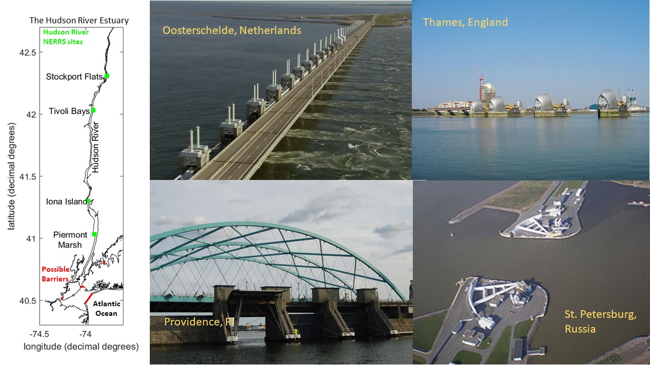
Our innovations in climate risk information have advanced based on stakeholder interests from mapping sea level rise effects on extreme flooding (Horton et al., 2015; Orton et al., 2015) to mapping its effects on recurrent tidal flooding (Supplemental Figure A; Orton et al., 2019; Patrick et al., 2019). Our research quantifying the importance of compound flooding in flood hazard assessment (Orton et al., 2012; Orton et al., 2018) has been influential toward NOAA’s evolving goal of integrated water modeling and forecasting. These innovations are captured in online flood hazard mappers (all linked from the Climate Resilience Toolkit) for NYC, NYS, Jamaica Bay (NYC), and Boston. This research has used hydrodynamic modeling to quantify the efficacy of nature-based adaptations that reduce flood risk (e.g., Marsooli et al., 2017) or conversely, the rise in risk that can occur from estuary urbanization (Orton et al. 2020; Li et al. in press). Educating the next generation of coastal climate service scientists has also been a focus. In two PhD dissertation projects, we evaluated metrics of gray infrastructure and climate change, including how gated storm surge barriers would perform under accelerating sea level rise (Z. Chen et al., 2020) and how grey structural flood protection affects human mortality risk (F. Zhang et al., 2020).
We have heard growing concerns from local governments and communities in NYC, Camden, Philadelphia and Boston about rainfall, river, sewer and compound flooding. For Phase III the “Coastal” sector will expand to become the Coasts and Floods Group by increasing our inland flooding capabilities. We have added hydrologist Marouane Temimi, who works closely with NOAA National Water Center on the enhancement of the National Water Model in the Northeast.
Research capabilities include flood and wave modeling (Marsooli et al., 2017; P. M. Orton et al., 2020), hydrologic modeling (Gonzalez et al., 2015), coupling of atmospheric and hydrological processes (Wehbe et al., 2019), remote sensing of hydrological processes (e.g., Temimi et al., 2011), in situ observation of soil hydraulic parameters (Al Jassar et al., 2019; Temimi et al., 2014), compound rainfall-river-coastal flood modeling (Orton et al., 2012; Orton et al., 2018), remote sensing of coastal processes (Chaouch et al., 2012), estuary circulation and water quality modeling hazard assessment (P.M Orton et al., 2015, 2016; P. M. Orton et al., 2018), damage and mortality modeling (P. Orton et al., 2016; F. Zhang et al., 2020), adaptation assessment (P. M. Orton et al., 2015), as well as operational coastal-hydrologic ensemble flood forecasting (Jordi et al., 2019).
Coasts and Floods Sector: Phase III plans
In Phase III, the Coasts and Floods Group will take on the following set of task areas, in addition to participation in Integrated Projects:
Provide on-demand climate risk information and research: This will build upon existing efforts for Philadelphia and NYC, but also including scheduled briefings with Jersey City, Camden and Boston to deepen these connections and address identified needs.
Study climate and urbanization impacts on inland, coastal and compound flooding, building upon our collaborative COCA/SARP-funded research (Orton and Montalto) and Orton’s NSF-funded research on separating climatic and estuary urbanization effects on flooding.
Quantify climate attribution for coastal flooding: In collaboration with the climate group above, we will operationalize estimation of effects of climate change within our real-time flood forecast system’s website, working with stakeholders to evaluate the impact.
Expand forecasting to include flood forecast mapping and improved communication. A deficiency in coastal flood observation systems is the lack of street-level observations, and we have begun deployments and research on webcam and ultrasonic sensor flood observations. These helps improve our models and enable flood forecast mapping.
Project publications
Mita, K. S., Orton, P., Montalto, F., Saleh, F., & Rockwell, J., 2023. Sea Level Rise-Induced Transition from Rare Fluvial Extremes to Chronic and Compound Floods. Water, 15(14), 2671. DOI: 2073-4441/15/14/2671. open access
Orton, P. M., Ralston, D., van Prooijen, B., Secor, D., Ganju, N. K., Chen, Z., Fernald, S., Brooks, B. and Marcell, K., 2023. Increased utilization of storm surge barriers: A research agenda on estuary effects. Earth’s Future. doi.10.1029/2022EF002991. open access
Chen, Z., & Orton, P. M., 2023. Effects of Storm Surge Barrier Closures on Estuary Saltwater Intrusion and Stratification. Water Resources Research, e2022WR032317, doi: 10.1029/2022WR032317. web | temporary free access
Pareja-Roman, L. F., Orton, P. M., & Talke, S. A., 2023. Effect of estuary urbanization on tidal dynamics and high tide flooding in a coastal lagoon. Journal of Geophysical Research: Oceans, 128, e2022JC018777, doi:10.1029/2022JC018777. open access
Ayyad, M., P. M. Orton, H. E. Safty, Z. Chen, and M. R. Hajj, 2022. Ensemble Forecast for Storm Tide and Resurgence from Tropical Cyclone Isaias, Weather and Climate Extremes, doi:10.1016/j.wace.2022.100504. web
Zhang, F., P. M. Orton, M. Madajewicz, S. C. K. Jagupilla, and R. Bakhtyar (2020), Mortality during Hurricane Sandy: The effects of waterfront flood protection on Staten Island, New York, Natural Hazards, doi:10.1007/s11069-020-03959-0. open access.
Orton, P., N. Lin, V. Gornitz, B. Colle, J. Booth, K. Feng, M. Buchanan, and M. Oppenheimer (2019), New York City Panel on Climate Change 2019 Report Chapter 4: Coastal Flooding, Ann. N. Y. Acad. Sci., 1439, 95-114, doi:10.1111/nyas.14011. open access
Patrick, L., W. Solecki, V. Gornitz, P. Orton, and A. Blumberg (2019), New York City Panel on Climate Change 2019 Report Chapter 5: Mapping Climate Risk, Ann. N. Y. Acad. Sci., 1439, 115-125, doi:10.1111/nyas.14015. open access
Gornitz, V., M. Oppenheimer, R. Kopp, P. Orton, M. Buchanan, N. Lin, R. Horton, and D. Bader (2019), New York City Panel on Climate Change Chapter 3: Sea Level Rise, Ann. N. Y. Acad. Sci., 1439, 71-94, doi:10.1111/nyas.14006. open access
Orton, P. M., F. R. Conticello, F. Cioffi, T. M. Hall, N. Georgas, U. Lall, A. F. Blumberg, and K. MacManus (2018). Flood hazard assessment from storm tides, rain and sea level rise for a tidal river estuary, Natural Hazards, 1-29, doi:10.1007/s11069-018-3251-x. web | PDF.
Kemp, A. C., T. D. Hill, C. H. Vane, N. Cahill, P. M. Orton, S. A. Talke, A. C. Parnell, K. Sanborn, and E. K. Hartig (2017). Relative sea-level trends in New York City during the past 1500 years, The Holocene, 0959683616683263. PDF | web
Orton, P. M., Hall, T. M., Talke, S., Blumberg, A. F., Georgas, N., & Vinogradov, S. (2016). A Validated Tropical-Extratropical Flood Hazard Assessment for New York Harbor. J. Geophys. Res., 121. doi: 10.1002/ 2016JC011679. open access
Brandon, C.M., J.D. Woodruff, P.M. Orton and J.P. Donnelly (2016). Evidence for Elevated Coastal Vulnerability Following Large-Scale Historical Oyster Bed Harvesting. Earth Surface Processes and Landforms, 2016; DOI: 10.1002/esp.3931. web
Orton, P. M., S. A. Talke, D. A. Jay, L. Yin, A. F. Blumberg, N. Georgas, H. Zhao, H. J. Roberts, and K. MacManus (2015). Channel Shallowing as Mitigation of Coastal Flooding, Journal of Marine Science and Engineering, 3(3), 654-673, DOI: 10.3390/jmse3030654. open access
Orton, P., S. Vinogradov, N. Georgas, A. Blumberg, N. Lin, V. Gornitz, C. Little, K. Jacob, and R. Horton, 2015. New York City Panel on Climate Change 2015 Report Chapter 4: Dynamic Coastal Flood Modeling, Annals of the New York Academy of Sciences, 1336(1), 56-66. web | PDF | NYCreport-PDF
Talke, S., P. Orton, and D. Jay, 2014. Increasing Storm Tides at New York City, 1844-2013, Geophys. Res. Lett., 41, DOI: doi:10.1002/2014GL059574. web
Meir, T., Orton, P.M., Pullen, J., Holt, T., Thompson, W.T., Arend, M.F., 2013. Forecasting the New York City urban heat island and sea breeze during extreme heat events. Weather and Forecasting. doi: 10.1175/WAF-D-13-00012.1. web
Orton, P., N. Georgas, A. Blumberg, and J. Pullen, 2012. Detailed Modeling of Recent Severe Storm Tides in Estuaries of the New York City Region, J. Geophys. Res., 117(C9), doi:10.1029/2012JC008220. web